


© Leica TPS-System 1000 Programs-2.3.1en 291
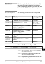
IV
EL
AH
OH
BS
SM
AS
FS
BL
HB
KM
FB
SA
PZ
LB
TB
CO
RP
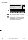
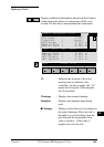
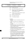
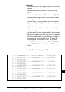
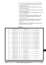
Data Formats The following describes the format and contents of the
data stored for alignments and cross-sections in the
RoadPlus program. All files are in GSI format and must
be located in the \GSI directory of the memory card.
The following geometric elements are supported:
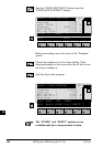
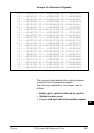
Horizontal Alignment
Element Definition Declaration in the
alignment file
Tangent Coordinates (X,Y) to Coordinates (X,Y) "STRAIGHT"
Circular curve Beginning of arc (X,Y), Radius, "000CURVE"
End of arc (X,Y);
Spiral In Beginning of curve (X,Y), A-Parameter / "00SPIRIN"
Length of curve + Radius,
End of curve (X,Y);
Spiral out Beginning of curve (X,Y), A-Parameter / "0SPIROUT"
Length of curve + Radius,
End of curve (X,Y);
Compound Beginning of curve (X, Y), Radius 1, "0CURVEIN"
curve in Radius 2
Compound Beginning of curve (X, Y), Radius 1, "CURVEOUT"
curve out Radius 2
End of Project Coordinates (X,Y) "00000EOP"
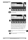
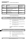
Header of the Horizontal Alignment File:
41....+000JOBID 42....+HZALIGNM 43......+STACOORD
WI 41 Job-Identification. Max. 8 ASCII-characters,
may be defined by user.
WI 42 Identification of Horizontal Alignment file.
May not be changed by user.
WI 43 Identification of principal point type file. May
not be changed by user.