


© Leica TPS-System 1000 Programs-2.3.1en 249
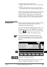
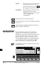
IV
EL
AH
OH
BS
SM
AS
FS
BL
HB
KM
FB
SA
PZ
LB
TB
CO
RP
Road Plus
Introduction
This manual describes the "ROADPLUS" program of
the TPS SYSTEM 1000 theodolite series.
The program allows for the stakeout of roads using the
typical offset method of construction staking. In
addition the program supports station equations, cross
section assignment by station, cross section definition,
cross section interpolation, superelevation, widening
and slope staking/catch points.
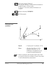
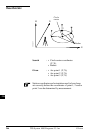
Alignment Definition
An alignment consists of the three basic components
which are horizontal alignment, vertical alignment and
cross-section template. "ROADPLUS" reads the
elements of each of these components from data files
that are in GSI file format. In addition, a file can be
created for entering cross-section stations for specific
locations such as points needed for the staking of
superelevation points. If station equations are needed,
"ROADPLUS" will read a file created for station
equations and apply the appropriate corrections.
Data Files
Each of the data files "ROADPLUS" reads contain the
necessary information specific to the component being
defined. The files have unique identifiers and must be in
the GSI file format:
Horizontal Alignment File ALN?????.GSI
Vertical Alignment File PRF?????.GSI
Template File CRS?????.GSI
Cross-section Assignment File STA?????.GSI
Station Equation File EQN?????.GSI