


Honeywell
MK XXII EGPWS Installation Manual
CAGE CODE: 97896 SCALE: NONE SIZE: A DWG NO: 060-4314-225 REV: C
SHEET
198
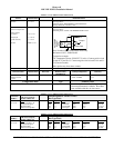
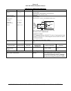
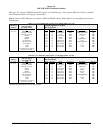
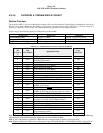
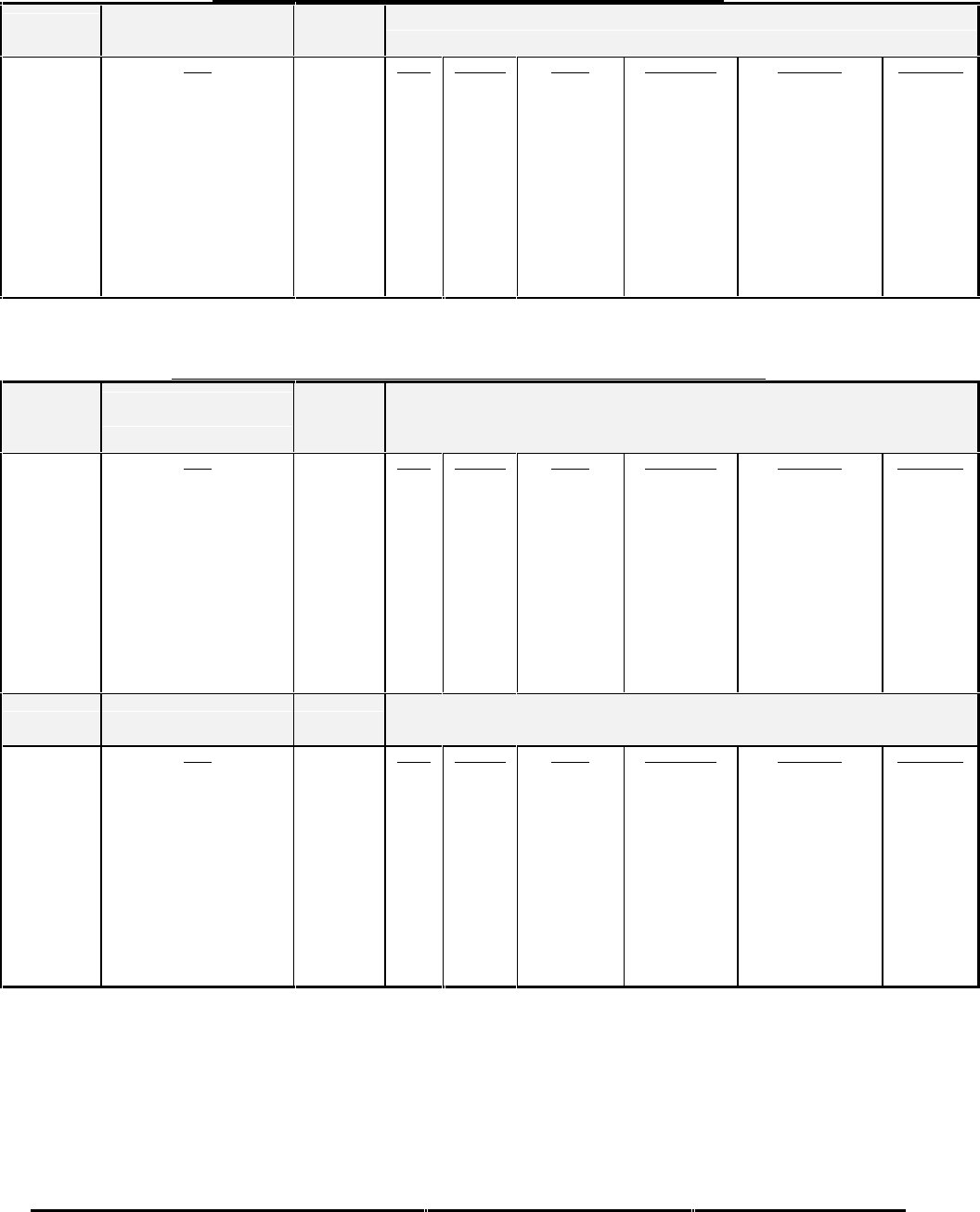
TABLE E 3.1.3-5: POSITION INPUT TYPE 5 (HIGH SPEED ARINC 743 GPS)
CHANNEL
429RX_4
CONNECT TO:
GPS (High Speed)
per ARINC 743
Fault Designation: GPS BUS
Bus Type: Basic
A = J2-25
B = J2-8
Data
Latitude - Normal
Longitude - Normal
GPS Hor. Int. Limit
Altitude
VFOM
HFOM
Ground Speed
True Track Angle
Sensor Status
**UTC
**Date
**This label is not required.
Data used if present
Label
110
111
130
076
136
247
112
103
273
125
260
Sig. Bits
20
20
17
20
15
15
15
15
19
19
19
Range
±180 Degrees
±180 Degrees
16 nm
±131,072 FT
1024 meters
1024 meters
±4096 Knots
±180 Degrees
Discrete Wd
Discrete Wd
Discrete Wd
Signal Type
Basic
Basic
Basic
Basic
Basic
Basic
Basic
Basic
Basic
Basic
Basic
Resolution
0.00017166137695
0.00017166137695
0.00012207
0.125
0.03125
0.03125
0.125
0.0054931640625
n/a
0.1 min
1 day
*Rate (ms)
1000
1000
1000
1000
1000
1000
1000
1000
1000
1000
1000
*Slowest acceptable update rate in milliseconds.
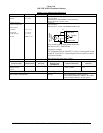
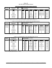
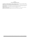
TABLE E3.1.3-255: POSITION INPUT TYPE 255 (DUAL HIGH SPEED ARINC 743A GPS)
CHANNEL
429RX_4
CONNECT TO:
GPS #1 (High Speed)
per ARINC 743A-2
Fault Designation: GPS BUS 1
Bus Type: Basic
A = J2-25
B = J2-8
Data
Latitude - Normal
Longitude - Normal
GPS Hor. Int. Limit
Altitude
VFOM
HFOM
Ground Speed
True Track Angle
Sensor Status
**UTC
**Date
**This label is not required.
Data used if present
Label
110
111
130
076
136
247
112
103
273
125
260
Sig. Bits
20
20
17
20
18
18
15
15
19
19
19
Range
±180 Degrees
±180 Degrees
16 nm
±131,072 FT
32768 ft
16 nm
±4096 Knots
±180 Degrees
Discrete Wd
Discrete Wd
Discrete Wd
Signal Type
Basic
Basic
Basic
Basic
Basic
Basic
Basic
Basic
Basic
Basic
Basic
Resolution
0.00017166137695
0.00017166137695
0.00012207
0.125
0.125
0.000061035
0.125
0.0054931640625
n/a
0.1 min
1 day
*Rate (ms)
1000
1000
1000
1000
1000
1000
1000
1000
1000
1000
1000
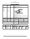
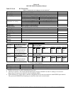
CHANNEL
429RX_7
CONNECT TO:
GPS #2 (High Speed)
per ARINC 743A-2
Fault Designation: GPS BUS 2
Bus Type: Basic
A = J2-23
B = J2-6
Data
Latitude - Normal
Longitude - Normal
GPS Hor. Int. Limit
Altitude
VFOM
HFOM
Ground Speed
True Track Angle
Sensor Status
**UTC
**Date
**This label is not required.
Data used if present
Label
110
111
130
076
136
247
112
103
273
125
260
Sig. Bits
20
20
17
20
18
18
15
15
19
19
19
Range
±180 Degrees
±180 Degrees
16 nm
±131,072 FT
32768 ft
16 nm
±4096 Knots
±180 Degrees
Discrete Wd
Discrete Wd
Discrete Wd
Signal Type
Basic
Basic
Basic
Basic
Basic
Basic
Basic
Basic
Basic
Basic
Basic
Resolution
0.00017166137695
0.00017166137695
0.00012207
0.125
0.125
0.000061035
0.125
0.0054931640625
n/a
0.1 min
1 day
*Rate (ms)
1000
1000
1000
1000
1000
1000
1000
1000
1000
1000
1000
*Slowest acceptable update rate in milliseconds.
Note: This configuration may not be selected if an AHRS configuration is required for Attitude and Heading information
(refer to Category 10 type 1 and Category 11 type 1), due to the conflict with Channel 429RX-7.