2 Command Descriptions
MiLLennium GPSCard Software Version 4.50 Command Descriptions Manual Rev 1 29
2.3 WAAS
The Wide Area Augmentation System (WAAS) is a safety-critical system that provides a quality of positioning
information previously unavailable. The WAAS improves the accuracy, integrity, and availability of the basic GPS
signals. In the future, the wide area of coverage for this system will include the entire United States and some
outlying areas. At the time of publication, there is one test satellite over the Pacific Ocean and therefore there is
only coverage for the western half of the United States.
The primary functions of WAAS include:
• data collection
• determining ionospheric corrections
• determining satellite orbits
• determining satellite clock corrections
• determining satellite integrity
• independent data verification
• WAAS message broadcast and ranging
• system operations & maintenance
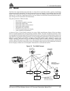
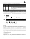
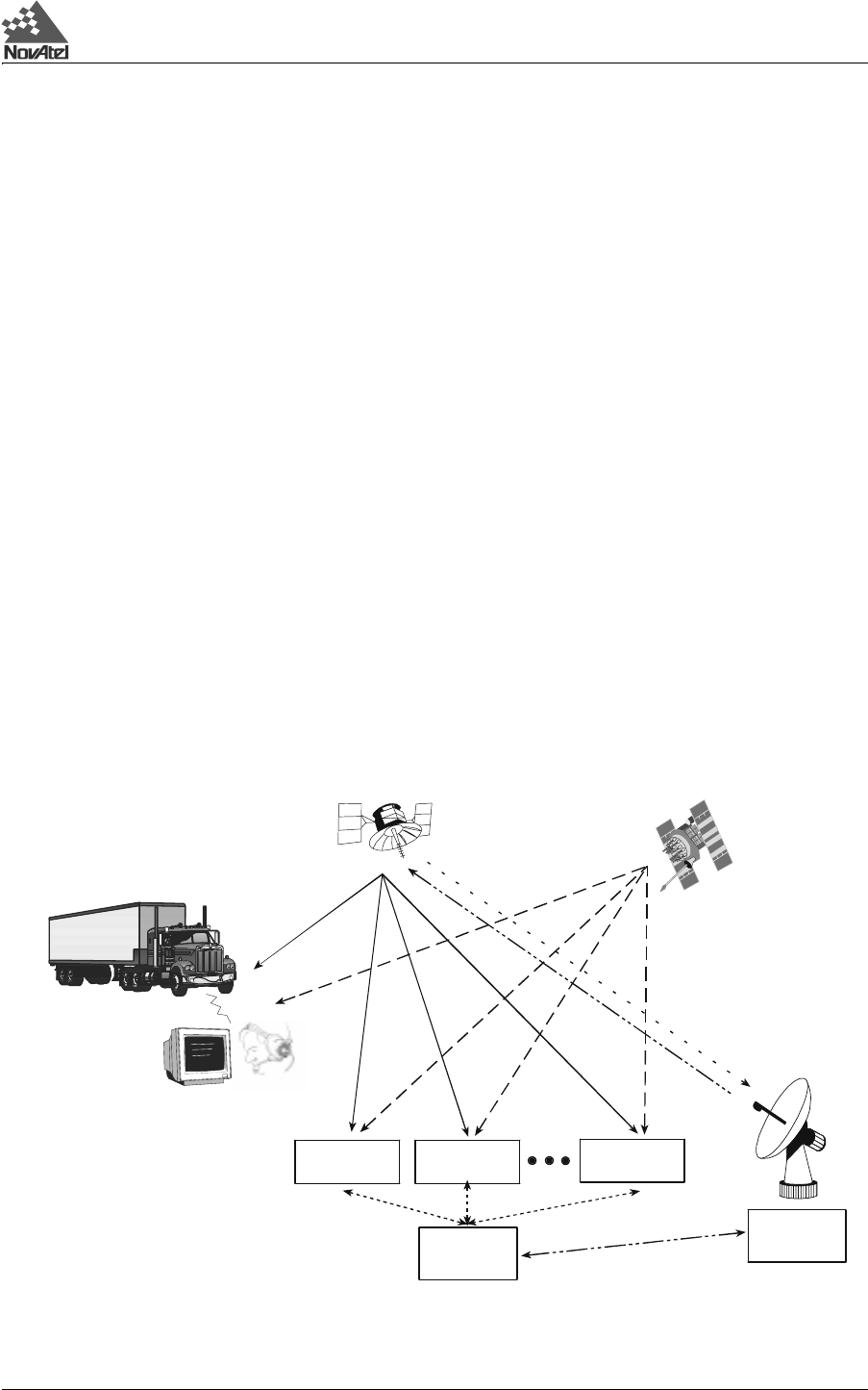
As shown in Figure 2-2, the WAAS is made up of a series of Wide Area Reference Stations, Wide Area Master
Stations, Ground Uplink Stations and Geostationary Satellites (GEOs). The Wide Area Reference Stations, which
are geographically distributed, pick up GPS satellite data and route it to the Wide Area Master Stations where wide
area corrections are generated. These corrections are sent to the Ground Uplink Stations which up-link them to the
GEOs for re-transmission on the GPS L1 frequency. These GEOs transmit signals which carry accuracy and
integrity messages, and which also provide additional ranging signals for added availability, continuity and
accuracy. These GEO signals are available over a wide area and can be received and processed by ordinary GPS
receivers. GPS user receivers are thus able to receive WAAS data in-band and use not only differential corrections,
but also integrity, residual errors and ionospheric information for each monitored satellite.
Figure 2-2 The WAAS Concept
Wide-area
Reference Station
(WRS)
Master Station
(WMS)
G
round Uplink
Station
(GUS)
Wide-area
I
n
t
e
g
r
i
t
y
d
a
t
a
,
d
i
f
f
e
r
e
n
t
i
a
l
c
o
r
r
e
c
t
i
o
n
s
,
t
i
m
e
c
o
n
t
r
o
l
,
a
n
d
s
t
a
t
u
s
Geostationary
Satellite (GEO)
GPS User
G
P
S
S
a
t
e
l
l
i
t
e
C
o
n
s
t
e
l
l
a
t
i
o
n
I
n
t
e
g
r
i
t
y
data,
d
i
f
f
e
r
e
n
t
i
al corrections
,
a
n
d
r
a
n
g
ing control
L1
C
-
b
a
n
d
L1 &
L
2
Reference Station
(WRS)
Wide-area
Reference
S
t
a
t
i
o
n
(WR
S
)
Wide-a
r
e
a
L1 & C-band


