


D Logs summary
178 MiLLennium GPSCard Software Version 4.50 Command Descriptions Manual Rev 1
POSA/B Computed Position
This log will contain the last valid position and time calculated referenced to the GPSAntenna phase centre. The
position is in geographic coordinates in degrees based on your specified datum (default is
WGS84). The height is
referenced to mean sea level. The receiver time is in
GPS weeks and seconds into the week. The estimated standard
deviations of the solution and current filter status are also included. See also Section A.3.2 Pseudorange
Algorithms, Page 67.
POSA
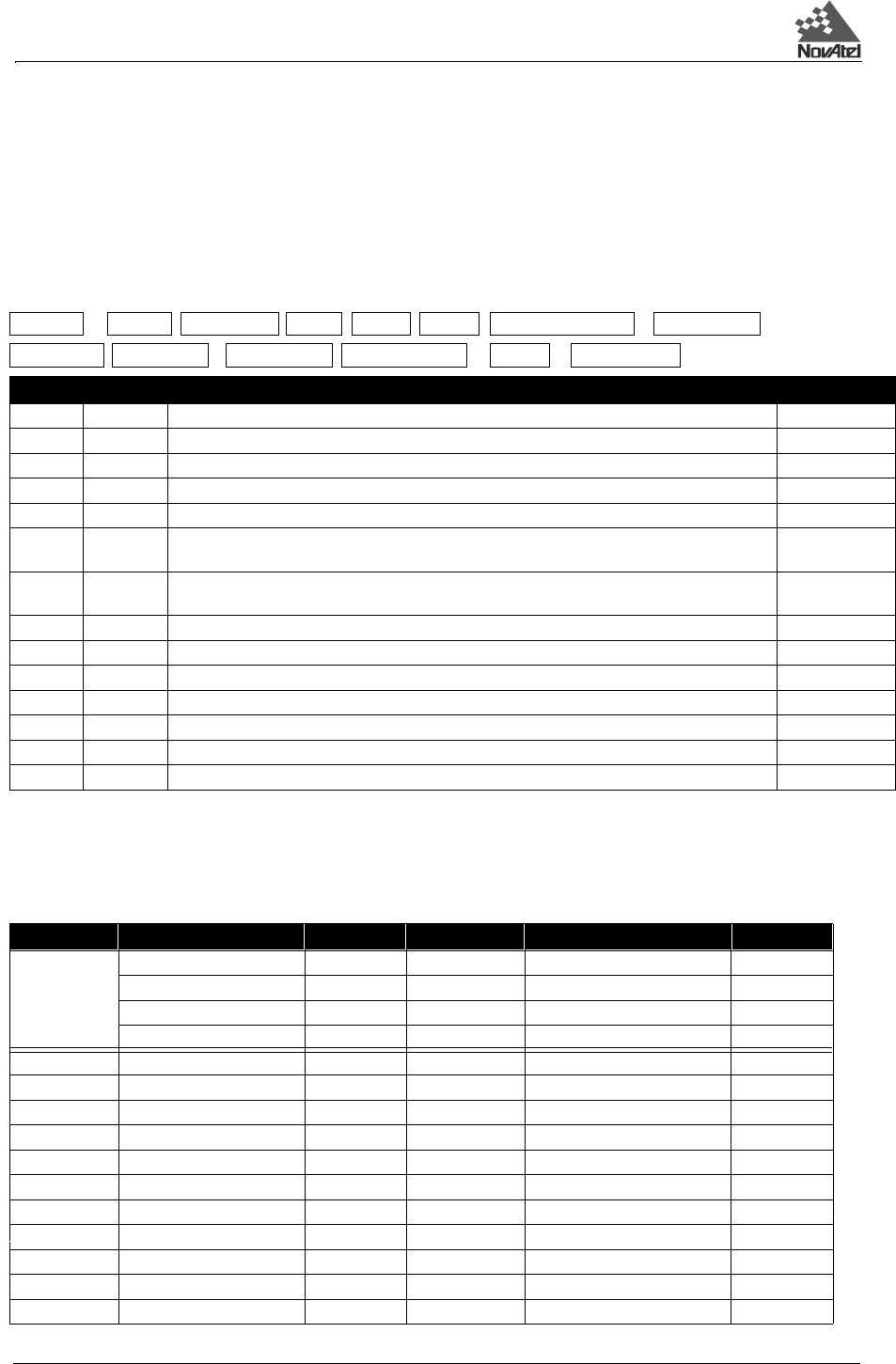
Structure:
Example:
$POSA,637,511251.00,51.11161847,-114.03922149,1072.436,-16.198,61,26.636,
6.758,78.459,0*12[CR][LF]
POSB
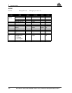
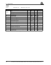
Format: Message ID = 01 Message byte count = 88
$POSA week seconds lat lon hgt undulation datum ID
lat std lon std hgt std sol status *xx [CR][LF]
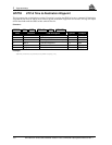
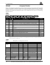
Field # Type Data Description Example
1 $POSA Log header $POSA
2 week GPS week number 637
3 seconds GPS seconds into the week 511251.00
4 lat Latitude of position in current datum, in degrees (DD.dddddddd). A - implies South latitude 51.11161847
5 lon Longitude of position in current datum, in degrees (DDD.dddddddd). A + implies West longitude -114.03922149
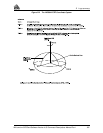
6 hgt Height of position in current datum, in meters with respect to mean sea level (see Figure D-2, Page
185)
1072.436
7 undulation Geoidal separation, in meters, where + is above spheroid and - is below spheroid (see Figure C-
6, Page 130)
-16.198
8 datum ID Current datum ID # (see Table G-2, Page 234 ) 61
9 lat std Standard deviation of latitude solution element, in meters 26.636
10 lon std Standard deviation of longitude solution element, in meters 6.758
11 hgt std Standard deviation of height solution element, in meters 78.459
12 sol status Solution status as listed in Table D-1 0
13 *xx Checksum *12
14 [CR][LF] Sentence terminator [CR][LF]
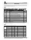
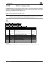
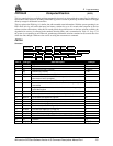
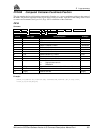
Field # Data Bytes Format Units Offset
1 Sync 3 char 0
(header) Checksum 1 char 3
Message ID 4 integer 4
Message byte count 4 integer 8
2 Week number 4 integer weeks 12
3 Seconds of week 8 double seconds 16
4 Latitude 8 double degrees (+ is North, - is South) 24
5 Longitude 8 double degrees (+ is East, - is West) 32
6 Height 8 double meters with respect to MSL 40
7 Undulation 8 double meters 48
8 Datum ID 4 integer 56
9 StdDev of latitude 8 double meters 60
10 StdDev of longitude 8 double meters 68
11 StdDev of height 8 double meters 76
12 Solution status 4 integer 84