C Commands Summary
MiLLennium GPSCard Software Version 4.50 Command Descriptions Manual Rev 1 117
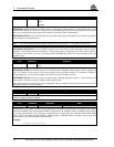
Station Command Argument Data
Remote rtkmode unknown_baseline (default)
known_llh_position
lat,lon,height,[2σ],[m/e]
known_ecef_baseline
∆x, ∆y, ∆z,[2σ]
RTKMODE UNKNOWN_BASELINE prevents the RTK system from using any baseline information in the initial
calculation of ambiguities. It cancels the effect of the RTKMODE KNOWN_LLH_POSITION or RTKMODE
KNOWN_ECEF_BASELINE command. It indicates to the RT-2 software that the previously entered baseline can no
longer be considered valid, usually because the antenna is starting to move.
RTKMODE KNOWN_LLH_POSITION LAT,LON,HEIGHT,[2
σ
],[M/E] requires the latitude, longitude and
height of the initial remote station antenna location. It can be used to initialize the RT–2 algorithms from a known
antenna position. It speeds up ambiguity resolution by indicating to the RT-2 software the exact length of the vector
between the remote and reference station antennas. It only affects the operation of an RT-2 system on baselines not
exceeding 30 km. LAT requires a decimal fraction format; a negative sign implies South latitude. LON requires a
decimal fraction format; a negative sign implies West longitude. HEIGHT (in meters) can refer either to mean sea level
(default) or to an ellipsoid. The optional 2
σ
defines the accuracy (2 sigma, 3 dimensional) of the input position, in
meters; it must be 0.03 m or less to cause the RT-2 algorithms to undergo a forced initialization to fixed integer
ambiguities. If no value is entered, a default value of 0.30 m is assumed; this will not cause an initialization to occur.
The optional M or E refers to the height: if “M” is entered, the height will be assumed to be above mean sea level (MSL).
Note that when an MSL height is entered, it will be converted to ellipsoidal height using the NovAtel internal undulation
table or the last value entered with the “UNDULATION” command. You may directly indicate an ellipsoidal height by
using the optional “E” flag.
Example:
rtkmode known_llh_position 51.113618,-114.04358,1059.15,0.01,e
RTKMODE KNOWN_ECEF_BASELINE
∆X,∆Y,∆Z,[2
σ
] can be used to initialize the RT–2 algorithms from a
known ECEF baseline. The RT-2 system uses this to initialize its ambiguities. It only affects the operation of an RT-2
system on baselines not exceeding 30 km. The
∆X,∆Y,∆Z values represent the remote station’s position minus the ref-
erence position, along each axis, in meters. The optional 2
σ
defines the accuracy (2 sigma, 3 dimensional) of the input
baseline, in meters; it must be 0.03 m or less to cause the RT-2 algorithms to do a forced initialization to fixed integer
ambiguities. If no value is entered, a default value of 0.30 m is assumed; this will not cause an initialization to occur.
Example:
rtkmode known_ecef_baseline 3583,2165,567,0.02
NOTE: You must be very careful when using these last two commands; erroneous input will cause poor performance
and/or erroneous output. It is also very important to follow these command with an RTKMODE
UNKNOWN_BASELINE command before any motion begins.


